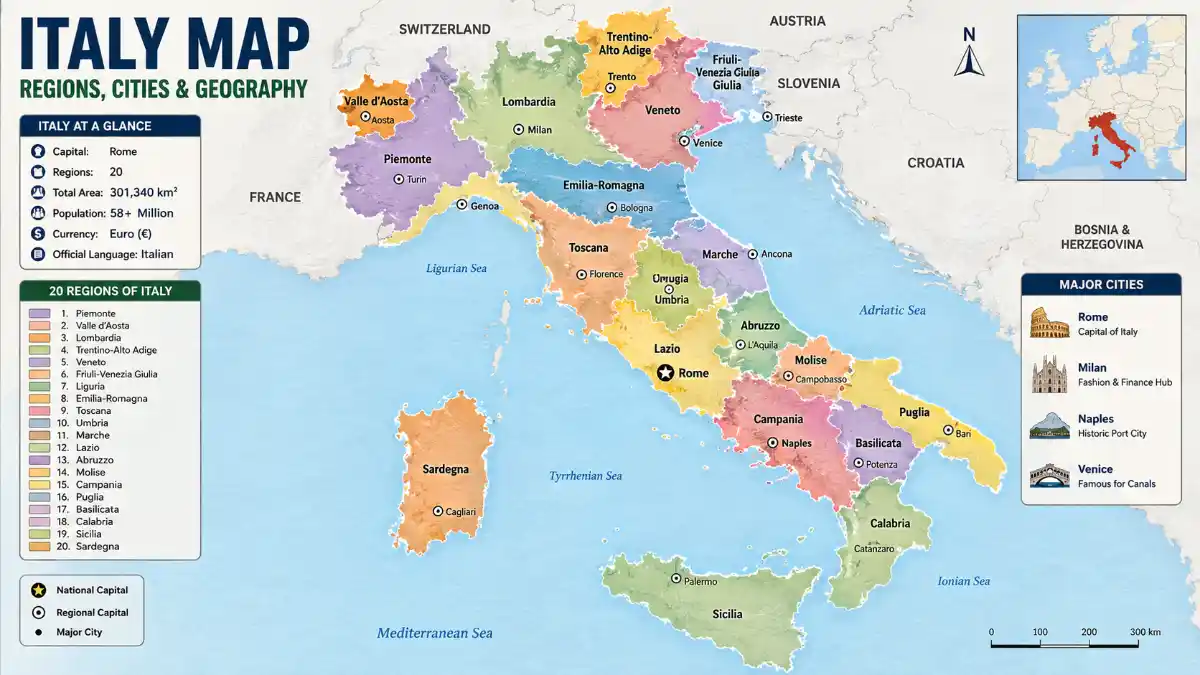

Italy’s boot-shaped peninsula stretches into the Mediterranean Sea, home to 20 regions, nearly 59 million people, and a mountainous spine that shapes everything from climate to economic activity. This guide walks through Italy’s political, physical, and tourist maps – with region-by-region breakdowns and practical examples for travelers, students, and researchers who need to understand how the country is laid out.
Italy Map Quick Overview
| Fact | Detail |
| Total area | 301,340 km² (116,350 sq mi) |
| Population | Approximately 58.9 million |
| Capital | Rome |
| Number of regions | 20 (5 autonomous) |
| Highest point | Mont Blanc, 4,810 m |
| Longest river | Po River, 652 km |
| Bordering countries | France, Switzerland, Austria, Slovenia |
| Enclave states | San Marino, Vatican City |
| Coastline length | Approximately 7,600 km |
| North-to-south length | Approximately 1,200 km |
Italy’s population has stabilized in recent years after more than a decade of gradual decline, with immigration now offsetting a falling birth rate.
Where Is Italy Located?
Italy sits in Southern Europe, extending as a peninsula into the central Mediterranean Sea, between latitudes 35° and 47° North. It shares land borders with France to the west, Switzerland and Austria to the north, and Slovenia to the east, with San Marino and Vatican City existing as independent enclaves fully surrounded by Italian territory.
Beyond the mainland, the country includes the islands of Sicily and Sardinia, plus nearly 800 smaller islands scattered along its coasts.
How to Read an Italy Map: A Beginner’s Guide
Reading a map of Italy correctly starts with separating three layers: political boundaries, terrain, and orientation. Most confusion comes from mixing these up.
- Identify north, center, and south – climate, culture, and cost of living shift noticeably across these zones.
- Locate the spine – the Apennine Mountains run down the middle, so major cities sit on the coast or in valley basins, not along the ridge itself.
- Check the islands separately – Sicily and Sardinia are often shown in inset boxes, which distorts their real distance from the mainland.
- Match color coding to regions, not provinces – political maps color-code the 20 regions, while provinces appear only as thin internal lines.
- Use the scale bar – Italy’s elongated shape makes it easy to underestimate distances, such as the roughly 1,400-kilometer road journey between Milan and Palermo.
Common Mistakes When Reading Italy Maps
- Assuming Sicily and Sardinia sit close together – they’re separated by about 280 km of open sea.
- Confusing Naples’ surrounding region, Campania, with the city itself when reading regional statistics.
- Underestimating north-south travel time, since mountainous terrain slows both road and rail speeds.
- Treating Trentino-Alto Adige as culturally uniform with the rest of the country, when it has a distinct German-speaking population near the Austrian border.
Read More: Italy Map
Italy Political Map: Regions and Administrative Divisions
Italy is divided into 20 administrative regions, five of which hold special autonomous status: Sicily, Sardinia, Friuli-Venezia Giulia, Trentino-Alto Adige, and Valle d’Aosta. These regions carry greater legislative independence, often tied to historical or linguistic factors, and are further split into roughly 107 provinces and metropolitan cities.
Northern Italy Regions
- Lombardy (capital: Milan) – the country’s most populous and wealthiest region
- Piedmont (capital: Turin) – bordering France, known for wine and industry
- Veneto (capital: Venice) – home to the canal city, Verona, and Lake Garda
- Emilia-Romagna (capital: Bologna) – a culinary and industrial hub
- Liguria (capital: Genoa) – the coastal “Italian Riviera,” including the Cinque Terre villages
- Friuli-Venezia Giulia (capital: Trieste)
- Trentino-Alto Adige (capital: Trento) – includes the Dolomites
- Valle d’Aosta (capital: Aosta) – the country’s smallest region, set in the Alps
Central Italy Regions
- Lazio (capital: Rome) – the capital region
- Tuscany (capital: Florence) – celebrated for Renaissance art and rolling countryside
- Umbria (capital: Perugia) – landlocked, often called the “green heart of Italy”
- Marche (capital: Ancona)
- Abruzzo (capital: L’Aquila) – mountainous, bordering the Adriatic
Southern Italy Regions
- Campania (capital: Naples) – includes the Amalfi Coast and Pompeii
- Puglia (capital: Bari) – the “heel” of the boot
- Calabria (capital: Catanzaro) – the “toe” of the boot
- Basilicata (capital: Potenza)
- Molise (capital: Campobasso)
- Sicily (capital: Palermo) – separated from the mainland by the narrow Strait of Messina; home to Mount Etna, Europe’s most active volcano
- Sardinia (capital: Cagliari)
Region Reference Table
| Region | Capital City | Population Density |
| Lombardy | Milan | High |
| Lazio | Rome | High |
| Campania | Naples | Very high |
| Sicily | Palermo | Moderate |
| Valle d’Aosta | Aosta | Low |
| Basilicata | Potenza | Low |
Read More: Italy Map
Why Northern Italy Is Wealthier: A Geographic Explanation
Northern Italy’s economic strength traces directly to its terrain. The flat, fertile Po Valley enabled early industrialization, while proximity to France, Switzerland, and Austria gave the region easier access to European trade routes than the mountainous, historically isolated south. Milan and Turin grew into manufacturing and finance centers partly because the terrain allowed efficient road and rail networks – an advantage the Apennine-dominated south never had at the same scale.
The south’s mountainous and volcanic landscape, including areas near Mount Vesuvius and Mount Etna, made large-scale industrial infrastructure harder to build, so its economy leaned more heavily on agriculture and, more recently, tourism. This geographic divide still shows up in income and infrastructure differences between the two zones.
Northern vs. Central vs. Southern Italy: Map Differences
| Feature | Northern Italy | Central Italy | Southern Italy |
| Economy | Industrial, financial hub | Government, tourism, agriculture | Agriculture, growing tourism |
| Climate | Continental, colder winters | Mediterranean, mild | Mediterranean, hot summers |
| Major cities | Milan, Turin, Venice | Rome, Florence | Naples, Bari, Palermo |
| Cost of living | Highest | Moderate to high | Generally lowest |
| Terrain | Alps, Po Valley | Apennines, coastal hills | Apennines, coastal plains, volcanic zones |
| Language variation | Distinct dialects, German in South Tyrol | Standard Italian dominant | Strong dialects (Neapolitan, Sicilian) |
Best Regions by Purpose: Travel, Study, or Relocation
Which region suits you depends on your goal – a traveler chasing coastline has different needs than a student seeking an affordable university city or a professional considering relocation.
- For travel: Tuscany, Campania, and Veneto offer the densest concentration of iconic sights within manageable distances.
- For study: Emilia-Romagna, home to the University of Bologna, one of the world’s oldest universities, and Lombardy offer strong academic infrastructure.
- For relocation and cost of living: Puglia and Calabria offer lower living costs than northern cities like Milan, though with fewer job opportunities.
- For business and finance: Lombardy remains the country’s undisputed economic center.
- For nature and outdoor activity: Trentino-Alto Adige and Valle d’Aosta, home to the Dolomites and Alps, suit hikers and skiers.
For first-time visitors, Lazio (Rome) is generally the most practical starting point, given its major international flight connections and easy rail access to Tuscany, Naples, and the Amalfi Coast.
Map of Italy with Cities: Where the Major Hubs Sit
Rome, Milan, Naples, and Turin are the four largest cities, each anchoring a distinct region and economic zone.
| City | Region | Role |
| Rome | Lazio | Political capital, historic center |
| Milan | Lombardy | Finance, fashion, design |
| Naples | Campania | Southern port, near Mount Vesuvius |
| Turin | Piedmont | Automotive, industry |
| Palermo | Sicily | Largest city on the island |
| Bologna | Emilia-Romagna | University city, food capital |
| Florence | Tuscany | Renaissance art hub |
| Venice | Veneto | Canal city on a lagoon |
| Genoa | Liguria | Historic maritime port |
| Bari | Puglia | Key Adriatic port |
Cities cluster densely across the northern Po Valley and along both coastlines, while the mountainous interior – particularly Abruzzo, Molise, and Basilicata – remains sparsely populated.
Italy Physical Map: Mountains, Rivers, and Terrain
Nearly 40% of Italy’s territory is mountainous, dominated by two ranges: the Alps in the north and the Apennines running the length of the peninsula.
The Alps and Apennines
The Alps form Italy’s northern border, shared with France, Switzerland, and Austria. The country’s highest point, Mont Blanc, rises to 4,810 meters on the France-Italy border. Within this range, the Dolomites in the northeast are famed for dramatic limestone peaks and hold UNESCO World Heritage status.
South of the Alps lies the Po Valley, Italy’s largest and most fertile plain, stretching from Piedmont through Lombardy and Veneto to the Adriatic near Venice – also the country’s most industrialized lowland.
The Apennine Mountains stretch roughly 1,200 to 1,350 kilometers down the peninsula’s center, continuing beneath the Strait of Messina into Sicily.
Major Rivers and Lakes
The Po River is Italy’s longest at 652 kilometers, flowing from the Alps into the Adriatic Sea. Other key features include:
- Adige (410 km) – flows through the northeast
- Tiber (405 km) – flows through Rome
- Arno (241 km) – flows through Florence and Pisa
- Lake Garda, Lake Como, and Lake Maggiore – the largest northern lakes near the Alps; Lake Como is known for its lakeside villas and mild microclimate, while Lake Garda is Italy’s largest lake by surface area
Surrounding Seas
- Tyrrhenian Sea – west coast, near Rome, Naples, and Sicily
- Adriatic Sea – east coast, near Venice and Bari
- Ionian Sea – south, near Calabria and Puglia
- Ligurian Sea – northwest, near Genoa and the Cinque Terre
Italy Tourist Map: Key Destinations by Region
Most visitors concentrate on five regions – Lazio, Tuscany, Veneto, Campania, and Sicily – connected efficiently by Italy’s high-speed rail network.
- Rome, Florence, Venice – the classic “Golden Triangle”
- Tuscany and Umbria – countryside and hilltop towns like Siena and Assisi
- Amalfi Coast and Naples – coastal scenery, Pompeii, Capri
- Cinque Terre – five clifftop fishing villages linked by coastal trails
- The Dolomites – alpine scenery and resorts like Cortina d’Ampezzo
- Sicily – ancient ruins, Mount Etna, Mediterranean beaches
- Sardinia – secluded beaches and a distinct regional culture
Example: Reading a Route from Rome to Milan
On a map, Rome and Milan sit roughly 477 kilometers apart by rail, cutting through Lazio, Tuscany, and Emilia-Romagna before reaching Lombardy. High-speed trains cover this route in about 3 hours, while driving takes closer to 5.5 hours over 570 kilometers, since road routes curve more around the Apennines.
Example: A Milan–Venice–Florence Loop
A common map-based itinerary works like this: start in Milan for fashion and finance, take a roughly 2.5-hour train east to Venice for its canals and lagoon, then head south for about 2 hours to Florence for Renaissance art before continuing to Rome. This route works efficiently because all four cities sit on Italy’s main high-speed rail corridor, unlike smaller towns off that line, which require slower regional connections.
How Geography Shapes Italy’s Transport Network
Italy’s rail network follows its terrain closely. High-speed lines run along the flatter Po Valley and coastal corridors, while mountainous interior regions like Basilicata and Molise rely more on regional trains and roads. This explains why itineraries built around Rome, Florence, Milan, and Venice feel seamless, while reaching interior towns in Abruzzo or Calabria takes noticeably longer despite shorter map distances.
Italy’s Size Compared to Other Countries
Italy is about 24% larger than the United Kingdom but roughly 45% smaller than metropolitan France.
| Comparison | Italy | Other Country | Difference |
| vs. United Kingdom | 301,340 km² | ~243,600 km² | Italy is about 1.24 times larger |
| vs. Metropolitan France | 301,340 km² | ~551,500 km² | France is larger by area |
| Population | ~58.9 million | UK: ~69 million | UK has more people despite less land area |
Political vs. Physical vs. Tourist Maps: What’s the Difference?
| Map Type | Primary Use | Key Features Shown |
| Political | Administrative reference, education | Regional borders, provinces, capital cities |
| Physical | Geography study, terrain planning | Mountains, rivers, elevation, coastlines |
| Tourist | Trip planning | Attractions, transport links, popular routes |
Choosing the right one depends on your goal – a road trip through the Apennines calls for a physical map, while researching the country’s government structure calls for a political layout of Italy’s regions.
Frequently Asked Questions
How many regions does Italy have?
Italy has 20 regions, five of which – Sicily, Sardinia, Friuli-Venezia Giulia, Trentino-Alto Adige, and Valle d’Aosta – hold special autonomous status with greater legislative powers, often due to historical or linguistic distinctiveness.
What countries border Italy?
Italy borders France, Switzerland, Austria, and Slovenia, plus the enclave microstates San Marino and Vatican City, which sit entirely within Italian territory.
Is Italy bigger than the UK?
Yes. Italy covers about 301,340 km², roughly 24% larger than the United Kingdom’s 243,600 km², despite the UK having a larger population.
How long is Italy from north to south?
Italy stretches approximately 1,200 kilometers from north to south, making it one of Europe’s most elongated countries and a key reason travel times vary so much between regions.
How far is Rome from Milan?
Rome and Milan are about 477 kilometers apart by rail and roughly 570 kilometers by road, with high-speed trains covering the distance in around 3 hours.
What is Italy divided into administratively?
Italy is divided into 20 regions, which are further split into roughly 107 provinces and metropolitan cities, the second-tier administrative units that handle local infrastructure and services.
What is the highest point in Italy?
Mont Blanc, at 4,810 meters, sits on the France-Italy border in the Alps. Gran Paradiso, at 4,061 meters, is the highest peak located entirely within Italian territory.
Which region is best to visit first in Italy?
Lazio, home to Rome, is typically the best starting point for first-time visitors due to major international flight connections and easy rail access to Tuscany, Naples, and the Amalfi Coast within a few hours.
Are Sicily and Sardinia part of mainland Italy?
Both islands are integral Italian territory, though geographically separate from the mainland. Sicily sits just off the “toe” of the peninsula across the Strait of Messina, while Sardinia lies further west, closer to Corsica than to the Italian mainland.
Is Italy larger or smaller than France?
Italy is smaller than metropolitan France, which covers about 551,500 km² compared to Italy’s 301,340 km², making France roughly 83% larger by area.